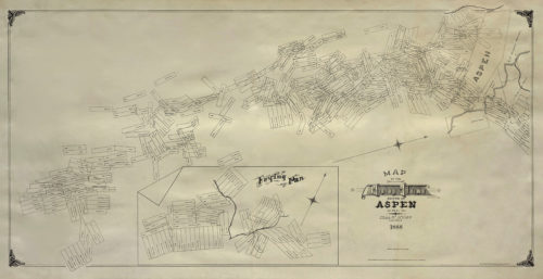
These rare maps, photographs, and documents will take you on a visual tour through Aspen in the late 1880s. Give your house a sense of place with a beautiful map or hand-drawn survey.

- One important, original drawing from 1891 is “Town Site of Aspen,” from the estate of John H. Marks, which shows all the original buildings in Aspen.
- This collection is the result of decades of careful selection by gallery owner and born-and-raised Aspenite, Mia Valley.
- Colorado had been a state for only three years when Aspen was established as a mining camp, one of the most remote in Colorado, in June 1879.
- The Gallery acquired these historical documents from the estate of John H. Marks, who was a U.S. Deputy Mineral Surveyor in Aspen during the mining boom.
- One remarkable map is a unique drawing dated 1891 measuring a staggering fifteen feet long! This detailed survey documents every building of the town site of Aspen all the way down to Woody Creek. It also traces the railroad’s path through the valley and the brisk, enduring Roaring Fork river.
- History and art lovers would both love, “A Matched Set of Maps of the Mining Claims North and South of Aspen.” These vintage maps show the entire town as well as the backside of Aspen Mountain, which many locals know as Little Annie Basin. Maps such as these would have been displayed in a mining office.
- Valley Fine Art has for sale the colorful, hand-drawn survey “Ranches of the Roaring Fork Valley,” which features the coordinates of town, the surrounding rivers, and likely showing ownership of various placers (claims) downvalley.
- The maps show the routes of the railroads. Railroads were an intraoral part of the mining industry, and a key element when looking to add a vintage map to a collection.
These are 8 great reasons to come to Valley Fine Art to observe these spectacular maps. Now is your chance to seize the rare opportunity to own a piece of Aspen’s wild west history.
